|
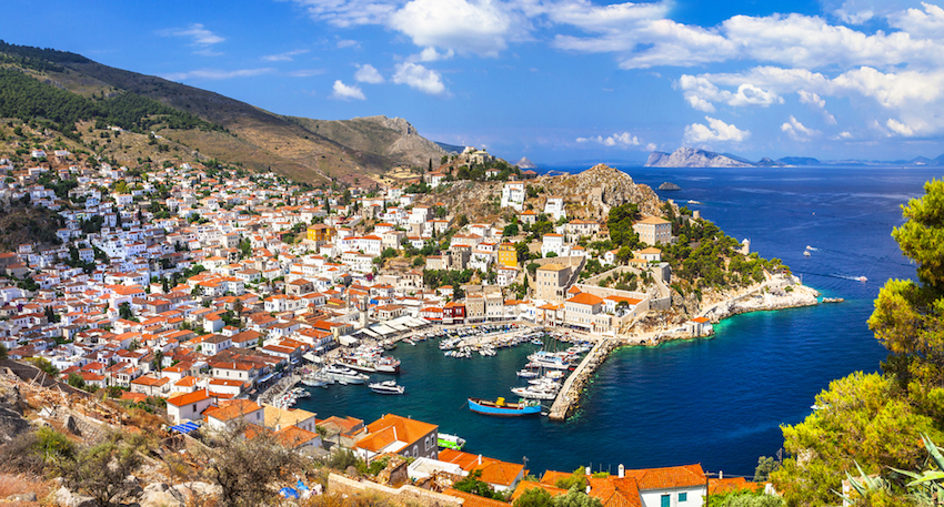
Besides being one of the most beautiful and easiest of the Greek islands to get to, Hydra has some of the best walking paths and donkey trails in Greece and is a paradise for hikers.
by Janet McGiffin
Janet McGiffin is the author of the four-volume Empress Irini series about the 8th Century Byzantine Empress Irini who was one of two women to hold the throne in her own right. Janet can be reached through her website, Janetmcgiffin.com
Hydra is variously known as the "museum" island kept as it was in the 1800s; the island of rich villas,
artists, and writers; the island where famous movies were made; and an island on the Three-Island-Cruise. Hydra
is more. For the strong of leg willing to tackle steep donkey trails and prickly gorse, Hydra has some of the best
spring and fall hiking in Greece. At Easter the island is carpeted with flowers, some of which exist nowhere else
on earth.
|
|
|
|
Sea Walks, Mountain walks, meadow walks
To promote its 1800s tourist ambiance, motor vehicles and bicycles are prohibited on Hydra. Three municipality
trucks cart garbage down a coastal road to the ever-smoking dump and an electric cart is an ambulance for people
able to get to the coast road. Beyond that, transportion is water-taxi, water-bus, or donkey, mule, and horse.
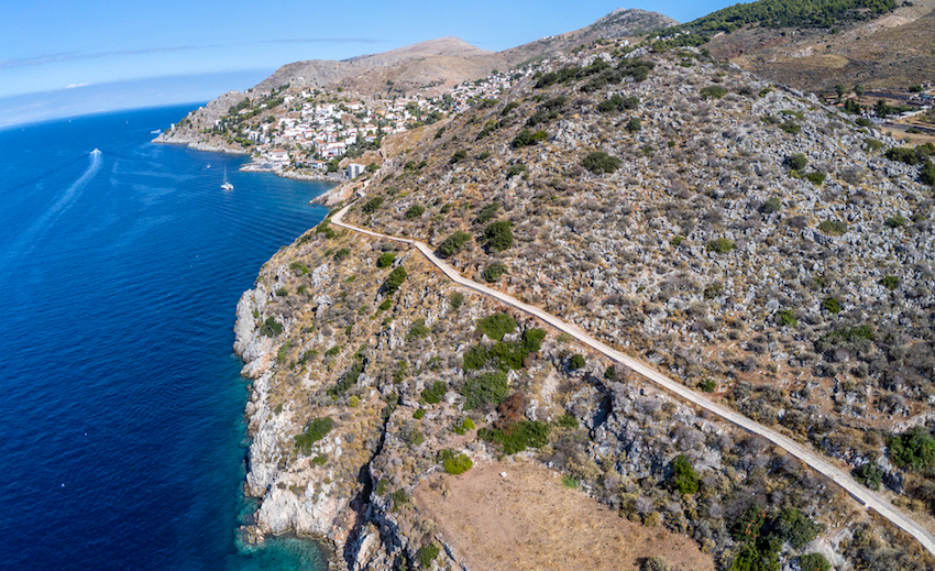
But mostly, it's your own feet. Beyond the narrow stone lanes and steps that climb the slopes of Hydra town, the
island is honeycombed with donkey trails that lead to hidden valleys, remote goat farms, monasteries, and tiny
beaches.
Hydra is long and shaped oddly like the constellation Hydra. From the main port east to the lighthouse takes at
least seven hours to hike. The same is true in the opposite direction. Trails are complicated to find, signposts
are confusing, and footpaths fork mysteriously. Maps show roads that don't exist. Consequently, most visitors find
only the beaches on the leeward (town) side and miss the spectacular high cliffs and vistas of the windward side.
Take heart. Hikers with stamina and imagination can locate the three main hiking routes and then veer off onto
branching trails using the sea to orient themselves. Here are three hikes that will cover Hydra to anyone's satisfaction.
|
|
|
|
Hike #1: Up and Over: Past the Profitis Ilias Monastery to the windward side
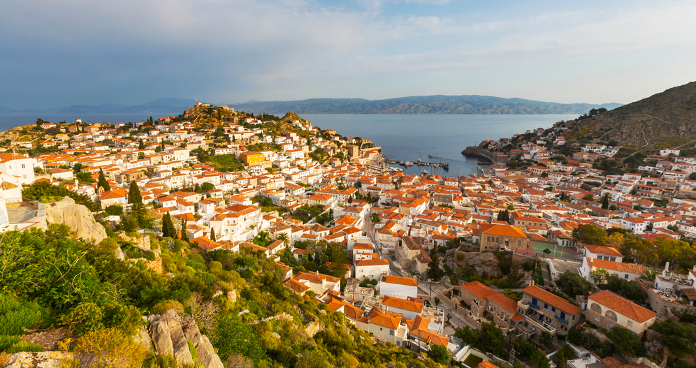
For a bird's eye view of the island, a great way to orient yourself, and the best hike for hot months, start with
the forest-shaded climb to the Profitis Ilias Monastery-the white compound perched on the highest hill above the
town, viewable only while approaching the island. (The two monasteries left of the harbor are Sts. Triada and Matronis.)
To get to the Profitis Ilias Monastery, set out from the ferry harbor via the "main street" of the town,
Miaolis Street, to the left of the Cathedral. At the top of the final switchback past the horse farms above the
town you will arrive at a tree-lined "avenue" that leads to the church of St. Constantine, patron saint
of the island. Don't go that far. Take the first abrupt left turn upward, a sharp U-turn. After a few turns, you
will reach a confused scramble of paths leading leftward. Scramble up one and you will find the pine-shaded trail
to the monastery.
Above the trees, the trail divides. A sign to the monastery points left. An island mystery. Actually, the monastery
entrance is to the right. So is the convent of St. Efpraxia. If you decide to climb the beautiful long steps to
the front gates of the monastery and look over the town and the mainland, take the right path. If you want spectacular
views of the monastery and the cliffs of the windward side, go left.
The left path follows a deep valley that curves around the monastery. Glance upward to the right to watch the massive
white monastery gradually come into view. The trail "ends" at a goat farm and a white cottage at the
top of a slope. Greet the goat owner politely. Now pay attention because it gets a bit tricky:
Look down the slope at an angle to the right. The monastery field stone wall drops to the bottom of the slope.
Head directly for this spot at the bottom. Nearing the stone wall, you will spot a sign haphazardly planted that
says "Mt. Eros." (This is NOT Mt. Eros, which lies far beyond the wall.) Place your right hand on the
sign and position yourself so that the sign and your arm are at 3:00 on an imaginary clock and you are facing 12:00.
You will see two faint paths ahead of you. One parallels the continuing stone wall. The other, at 10:00, is your
path. Relax, it gets more defined.
Follow this path through the trees. Gradually climb for ten or fifteen minutes. When this path curves definitely
to the left, scan the trees to the right for a well-defined path that departs at 90 degrees. Take this path. Within
a few minutes, you will see the vast sea and sweeping slopes of the windward side.
The trail now drops steeply downward in switchbacks. Stop here. It does not lead to a beach. It is used by goat
herders to reach their farms. If you have a whole day ahead of you and are ready for many hours of hiking, go ahead.
Evenutally, you will curve left and hike around the island to arrive at the Monastery (convent) of St. Nicholas.
If you reverse your steps, turn left when you reach the "avenue" of trees and visit the shade under the
veranda of the church of St. Constantine. Descend the steps on the far side of the church, circle left around the
two small churches, make a quick right, circle left around the next church (don't worry, it's obvious when you're
there) and wind your way down to the harbor through the tiny lanes.
|
|
|
|
Hike #2 Zourvas Monastery and the Lighthouse
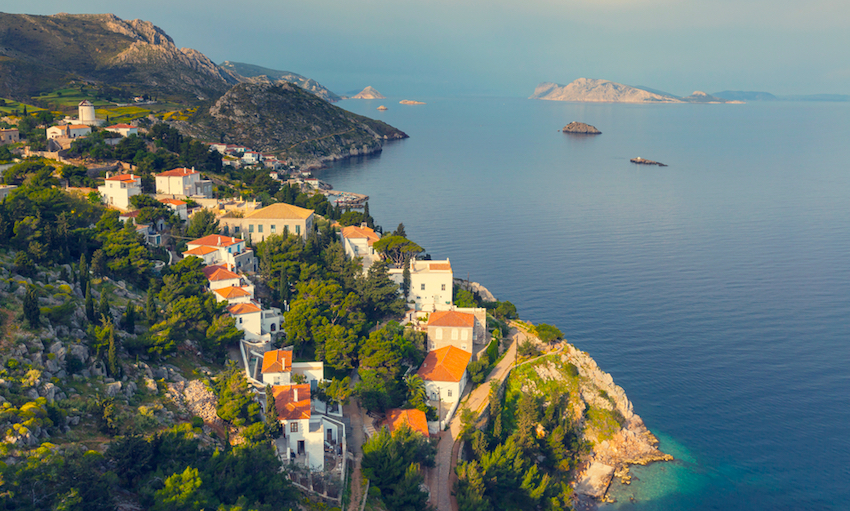
The absolute best way to enjoy the long Zourva Monastery hike is to spend about 25 Euros and hire a water taxi
to take you to the white flights of steps that lead up the cliff. Then hike back. There are reasons.
1. This is
a long hike with little shade and an upward slope. You might turn back before you reach the best.
2. Signs leading
to the Zourva Monastery are ambiguous and directions are complicated. The route back is easy to follow.
3. Best
views are from Zourvas toward Hydra town.
4. At Zourvas, you can add an hour's detour to the lighthouse on goat
paths, or turn toward town on the well-maintained donkey trail.
Whatever you choose, the trail is delightfully varied in terrain, vistas, and vegetation. Bring lots of water
and a nice lunch.
Assuming you start from Zourvas, while catching your breath at the top of the stone steps, look around for wild
sage and wild gladioli (in spring). Take a peek through the monastery gates, then head back towards town. It's
straight on 'til morning. Seriously, this is a long hike. Pass a goat farm (at a distance-beware of dogs). Hours
down the trail, (remember, this is a long hike!) rest at the lovely tiny white chapel of Profitouiliou, well-marked
by a votive church planted in the footpath.
The Monastery (convent) of Agios Nicholaos marks the approach to civilization and a choice of route. One road down
turns right, down to the smoking dump, the 4-star Hotel Miramare, and the abattoir. Not my personal choice, although
the Miramare does serve a decent lunch, as does the nearby taverna.
Another road goes left, to the windward side, a full day's hike in itself, eventually leading to the steep zig-zag
trail up to the Monastery of Profitis Ilias.
The best route is straight ahead on a fairly wide road that leads between the visible monasteries of Sts. Matronis
(left) and Triada (right). After you pass the Triada Monastery, a narrow trail angles up to the left. Take this
left trail up to the round stone tower you can see ahead on the bluff. From there it drops down a lovely pleasant
valley with charming views of the town. You will finish at the main cemetery at the top of the town. Continue to
the harbor on the wide main street or circle the cemetery and take the street from the cemetery to the harbor.
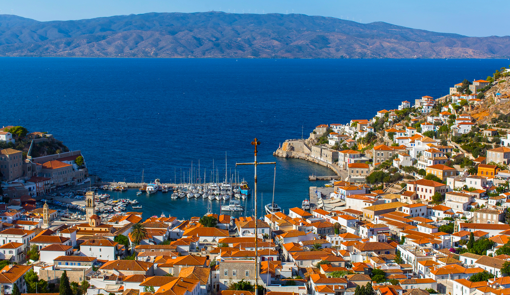
However, if you're ready for a precipitous drop down the cliff that overlooks the town, with spectacular views
of the town, the farther islands, the mainland, and straight down into expensive walled villas, continue straight
ahead along the road. When you reach a stone wall at the bluff, veer right along the path, keeping the stone wall
on your left. A cold beverage awaits you at the port in half an hour.
|
|
|
|
Hike #3: The Byzantine town of Episkopi
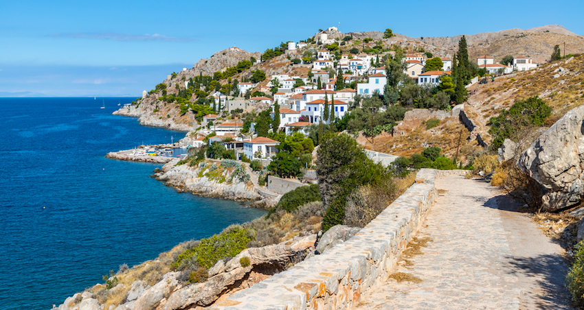
This hike follows the sea past numerous swimming beaches, so take your swimsuit. It is the flattest of the three
routes. Leave Hydra town by way of the sea promenade heading toward the fishing village of Kamini. Pick your way
around the beached fishing boats there and continue along the sea. The flagstones of the walkway end at the Kamini
swimming beach. Continue on the dirt road to Vlihos.
On the cliff above the Vlihos beach, your road turns inland and crosses a stone arched bridge. Note this spot for
your return. Rising to your left is a stone walkway that is a delightful return into Hydra town. This footpath
passes through meadows, past another cemetery, and connects with the upper town. As an evening walk, it is the
ultimate in peace and serenity.
For now, continue onward along the sea through Vlihos to the "dry-dock" at Palamida. (You can take a
water taxi to this point.) The road curves inland now and climbs the hill. Eventually you will reach a cluster
of houses called Episkopi. Reputedly the site of a Byzantine village, Episkopi is now goat farmers and people who
like to be remote. At the end of the roughest stone road of your life is a gate. You have reached the far side
of the island.
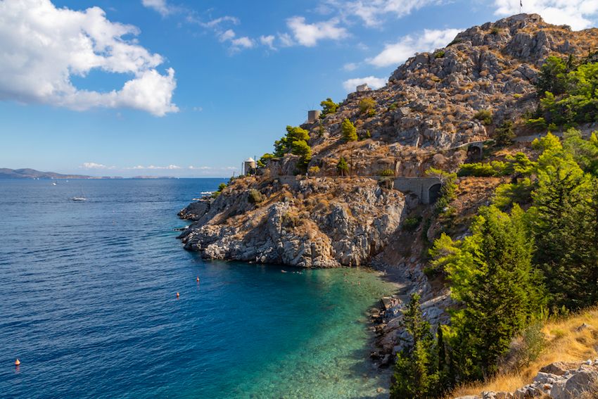
At the bottom of the onward path is a swimming cove, far far below. Climb the gate and veer left across stony pasture.
The path is visible in the trees ahead.
|
|
|
|
Advice for hiking on Hydra:
Wear strong hiking sandals or walking shoes although Hydriots are notoriously tough and ample down these paths
in street shoes. Ointment helps for those pesky nettles and donkey thistles.
Bottled water only. Hydra's picturesque wells (pigadia) are low so tap water is barged in from the Peloponnese,
then pumped into tanks at the harbor and to the top of the town. The water is brackish and creates thirst. Most
Hydriots maintain a cistern (sterna) under their houses to store delicious winter rainwater which they drink all
summer.
No Camping. Where to stay. Camping is prohibited and enforced by island police. This is a "museum" and
they like their landscape decorated by donkeys and goats only. Hotels run 50 Euros or more per night although there
are lesser-expensive pensions and rooms-for-rent posted around town. During summer, book ahead or arrive early
so as to depart for the mainland if you can't find lodging.
Wear sunscreen, hat, long-sleeved white shirt and trousers. Summer is not the time to hike on Hydra. Hydra's reputation
as the hottest of Greek islands is well-deserved. The curve of the Peloponnese blocks sea winds and the breezes
do little to lighten the scorching summer heat. If you must hike after Easter or before September, start before
dawn and be back before noon. Walk slowly, rest often in shade, wear a long-sleeved white shirt and long loose
cotton trousers. Short-sleeved shirts and hiking shorts will give you sunburn and increase body water loss. Drink
water.
Or-a delightful experience-set out on shorter hikes an hour before sunset and return under those incredibly brilliant
stars and moon. Starlight reflected off the sea is a sight to remember.
Snakes, scorpions, and spiders. I have hiked on Hydra for years and never seen any of these. Rumors says they exist,
but obviously in limited numbers.
Bird -watching The EU edict against shooting migrating bird doesn't seem to have reached 18th century Hydra. There
are fewer birds than shotgun shells littering the trails. Chat while you hike or tie a goat bell to your knapsack
to make sure you aren't mistaken for a bird.
Mobile phone service. Some people feel safer carrying a mobile phone. On Hydra, phones have limited benefit since
the lack of roads make it difficult to pick a injured person off a remote slope. There is no server on the windward
side and the rock mass blocks reception.
Greet people immediately and politely with Yia Sas, or Heretay (greetings) Hydriots are reserved people who most
likely get tired of seeing tourists. Greet everyone politely, first. You will be amazed at the immediate smile
that comes with the reply.
Hiking is getting popular in Greece and Greek map companies have charted most Greek island hikes. However, Hydra
is still undiscovered by maps or Greek hikers. You'll spend hours encountering few people, hearing only the breeze,
the sea, and the occasional bray of donkeys.
UPDATE! Paths of Greece has done a lot of work here on Hydra and the trails are now marked well. They even have a hiking map posted right near the donkey stands which shows all the loops with distance and time info. A large improvement.
For more on the island of Hydra visit Matt's Hydra Guide
|
|
|
|
To get to Hydra
Car ferry from Piraeus Harbor makes a round trip daily to Aigina, Methana, Poros, Hydra, Spetses and sometimes
Porto Heli at 8 a.m. in summer, with an afternoon ferry during certain summer months, depending on demand. The
trip is 3.5 hours. Three hydrofoil companies serve Hydra in summer, depending on month
and demand. Prices are generally twice the ferryboat ticket at half the travel time. Book ahead by phone or arrive
well in advance for tickets in summer. If you are visiting the Peloponnese, bus to Methana and catch the ferry
or hydrofoil from there, or bus to Hermioni and hydrofoil from there. You can find ferry schedules at www.ferryhopper.com and there is more info on Matt's Getting to Hydra Page
You
can book hotels by contacting Fantasy Travel
or Dolphin Hellas
You can find hotels on Matt's Hydra Hotels Page and Villas and holiday homes on Matt's Hydra Villas Page. You can also research and book hotels through Booking.com's Hydra Pages
Janet McGiffin lives in Athens partly because it is so easy
to travel to anywhere from Greece. She is a writer of mystery novels and travel
articles. She also writes grant proposals for non-profit organizations (NGO)
based around the Mediterranean. Currently she is public-education publicist for
a 24-partner European Union cultural project involving conservation of ancient
monuments. You can e-mail her at mcgiffin@otenet.gr
|
|

